Eeevvvvrybodddyyy.... sing along!
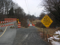
Anyway, there is new signage and pavement marking going up on the trail. Last night on my ride home I noticed the new "ROAD XING" markings on the pavement, along with pseudo-rumble-strips. Today I noticed an additional signpost at road crossings, announcing the road name and town, such as "Gallows Rd. Dunn Loring". Should be a big help for riders unfamiliar with the trail. And while I think the rumble strips might be silly, at least they aren't too bumpy.
At about 9:30 this morning, the crews were getting set up around Sandburg Road, apparently working eastward.
Tim
Friday, March 30, 2007
Thursday, March 29, 2007
Please report graffiti

As the warmth and sunshine have greened the edges of the trail, the annual opening of graffiti season has inevitably followed. The park authority folks try very hard to remove or cover graffiti as soon as possible. Trail users can help out by notifying the park folks of the location of new vandalism. Just send an email message to: wod@nvrpa.org and give a brief report on the location. Photo shows graffiti on shelter at Mile 4.
Beautiful Riding Weather

It would be difficult to imagine more pleasant conditions for a ride on the W&OD Trail. This photo was taken near Mile 40, about five miles southeast of Purcellville, Virginia, that is, halfway between Leesburg and Purcellville. Enjoy!
Sunday, March 25, 2007
Dove love

The weekend started in a cloud and ended in a sunbeam. Both days the trail was filled with riders, walkers and birdsong. You could not miss the Mourning Doves. Their soft "Coah cooo cooo coo" coming from all sides. Mourning dove males call to mark their territory and to woo the demure females. The males also choose a nest site, but their nests are notoriously flimsy. Sometimes they don't even bother making one themselves, but instead use old Robin nests! When the two chicks hatch, both parents take turns feeding them crop milk (also called pigeon milk). The babies grow and fledge very fast, and a pair of doves may raise 2-5 or even 6 broods a year. Good thing. They are prey to many birds and mammals. Photo courtesy Fairfax County Public Schools.
Tuesday, March 20, 2007
Repairs to Broad Run Bridge completed
Repair work on this bridge near mile 24.5 (0.5 miles northwest of Route 28) is finished. It's a great improvement.
Monday, March 19, 2007
Safety Enhancements on Trail
Monday, March 19, 2007. The trail is clear all the way
from Leesburg to Clarks Gap . There's some snow
at the stone bridge at Clark's Gap but very passable.
I noticed these trail markings at all the Leesburg intersections along with rumble strips. This one is just before Catoctin Circle near the high school.
The work crews use hot torches to seal the lettering and I needed to walk my bike around their work at one point.
All in all a great ride with a stiff tailwind westward (uphill when I needed it) with gravity negating the headwind (almost) on the way back.
from Leesburg to Clarks Gap
 . There's some snow
at the stone bridge at Clark's Gap but very passable.
I noticed these trail markings at all the Leesburg intersections along with rumble strips. This one is just before Catoctin Circle near the high school.
The work crews use hot torches to seal the lettering and I needed to walk my bike around their work at one point.
All in all a great ride with a stiff tailwind westward (uphill when I needed it) with gravity negating the headwind (almost) on the way back.
Sunday, March 18, 2007
Frog Thaw
 Trail ride today involved a stupefying headwind westbound, and near liftoff eastbound. But as Tim notes, it is clear clear clear all the way. If you ride through the Difficult Run Valley west of Vienna, listen for the Wood Frog. We heard them today: a kind of quacking or tapping call. The frog has a little bandito mask, like a raccoon, and is one of the few animals that can freeze but not die. When winter comes it buries itself and then goes into a deep hibernation where it stops breathing and its heart even stops. It becomes a frogsicle! When it warms and thaws, it starts calling right away. These little guys are found all the way up to the Arctic Circle. Photo courtesy of Kidzone.
Saturday, March 17, 2007
Vienna to FC - All Clear!
 Pretty amazing what a difference 10 hours can make. This was taken Saturday evening, at about 6:30, on my way home. It's around mile 10.5, as I recall, and as you can see, the trail is clear. The whole stretch from Vienna to Falls Church was clear and dry, with the exception of the bridge over the beltway, which had some ice on the right hand side (heading east), but still had plenty of clear, open surface.
This picture shows what the bridge looked like tonight at around 6:45. Not bad at all, especially compared to this morning!
Crunchy AND Slick
 Well, it's no longer like pineapple sorbet! This morning, at around 8:30 - 9:00, the trail was covered with a thin crust of ice/snow, with a texture like cornflakes. And it's about as loud as that too. Kind of slippery, but not deadly slick. I was glad to have the studded tires, but it's probably manageable without, as long as you're careful. There are clear patches, but most of the trail was covered this morning. By later today, depending on sun and temperature, it should be better, but still messy.
To the right is a shot from just east of the bridge over the beltway, near Virginia Lane. If you squint, you can see the fence on the bridge in the distance.
Hi Mom!
 As commutes go, last night's introduced me to new bicyling territory. From Arlington to Falls Church the sleet and freezing rain kept me very alert --- not to mention exfoliating my complexion. At about the Rt. 7 bridge, the ice began to build up on Idabike, including cables, which I discovered turn out to be fairly important to braking ability. But who needed to brake anyway? I began to get a good workout as the ice collected around the brake shoes and dragged on the wheels. It was like riding through pineapple sorbet while towing a shrubbery. I was long overdue at home and my son walked out to the trail to wait for me. While he was waiting, he made a sign in the slushy ice on the trail.
 Friday, March 16, 2007
Wormicide

 35 F and a driving rain for my commute this morning. I kept puzzling over why I had the trail entirely to myself. Then it hit me. I was in the company of tens of thousands of earthworms, all driven from their burrows by the rain, all moving across my path. I could not avoid all of them. It was Serial Wormicide. Obviously people were avoiding the trail to keep from killing worms. The flocks of Robins in Falls Church and Arlington had no such compassion. They had eaten so many worms they were barely able to fly. Some just stood by the trail in a stupor, eyes half shut, like a teenager that has just finished off a large pizza and a root beer float.
Trail user alert: Four mile run was bank full when I rode by this morning (left photo about mile 4.5). I have had to ride through water over the trail at this spot, so be careful to wear your water wings if your commute takes you this way tonight.
If you make it that far west, pause by Cedar Lane to see the Pussy Willows (right photo just west of Cedar, almost mile 10).
Wednesday, March 14, 2007
Vienna to Mile 30
Wednesday was a great day for a ride, and lots of folks were out enjoying the trail.
Bridge work continues at Broad Run, but it looks like it is nearly complete. Here's hoping that will be done soon. The new surface is much, much better.
Tree trimming was happening around mile 26, and I'm assuming will continue for a while.
Just west of Vienna, the marshes were alive with spring peepers, and some other species of frog with a deeper sound. Not one I recognized, but perhaps our resident expert (that's you Penny) can clue us in. Also spotted and heard a number of hawks, including Broad Winged and I think Red Shouldered. Oh, and one ground hog seemed completely unimpressed with our presence... he sat right at the edge of the trail, less than 3 feet from me, and just looked bored as I went by him.
Tuesday, March 13, 2007
Marsh Marigolds and Spring Peepers

 The trail was very crowded today as the warm weather and late light brought people out of their homes and cars. Take care: many of these folks are not familiar with trail etiquette and some have a tendency to wander all over the place, allow their dog leashes to stretch across the path, and let their youngsters wobble into oncoming trail traffic.
The wildflowers are starting to show themselves. Marsh Marigolds are in bloom in Banneker Park near Mile 5 (left). Better yet, the Spring Peepers (right) are calling evenings in the wetlands along the trail. Actually, it is the males that are calling. In case you don't know what these little frogs sound like, this Fairfax County web site has a couple of good recordings and numerous photos. http://www.fcps.edu/islandcreekes/ecology/spring_peeper.htm
Monday, March 12, 2007
Pack of Cats Sighted on Saturday

Catrikes, that is! Our Saturday ride consisted of all Catrikes from an early model to the latest Catrike 700 & Expedition. The cats prowled the trail from Rt. 28 to Leesburg and back. If we got all of our group together, there'd be 8 Cats! Have fun out there!
FC to Vienna - tree trimming and hawks!
Well, the trail is clear, the weather was gorgeous, and people are slowly starting to emerge from their winter burrows. There was a crew trimming trees along the trail, near mile 10, as I recall. Not completely blocking the trail, but blocking one lane. It's that time of year, so keep your eyes peeled all along the trail for trimming.
Just east of Park Street, I saw a red-shouldered hawk alight in a tree. Stopped to watch for a moment, when he was joined by another one. After a few moments, the second one flew off to another tree, where they apparently have a nest. It looked like she might be feeding young, but it's kinda early for that, so maybe not.
Just east of Park Street, I saw a red-shouldered hawk alight in a tree. Stopped to watch for a moment, when he was joined by another one. After a few moments, the second one flew off to another tree, where they apparently have a nest. It looked like she might be feeding young, but it's kinda early for that, so maybe not.
Saturday, March 10, 2007
Vienna to FC - Clear trail and PEEPERS!
Rode home from the shop Saturday evening, just after dark. No snow on the trail any more, just a little on the sides. And near the Cedar Lane crossing, I heard my first spring peepers tonight! Woo hoo!
Progress on Broad Run bridge repairs
Repairs have been completed on one side of the bridge located near mile post 24.5, about 0.5 miles northwest of Route 28. Crossing the bridge is now safer and no longer bone-jarring, but still restricted to one lane.
Friday, March 9, 2007
Falls Church - Vienna: Mostly Clear and Bluebirds!

 The trail is in pretty good shape from Falls Church to Vienna. As you can see to the left, the bridge over the Beltway still has a fair amount of snow/ice on it, but the north side is clear. Most of the trail is wide open and dry.
No surprise here, but the section between Gallows and Cedar still has some messy spots in the shade. On the right is the area by milepost 9.5, where you can see the snow is still edge to edge. It's mostly just packed snow, but there is some ice, including some hiding below the snow. Luckily the surface isn't too bumpy from footprints, so it's not terrible riding. And the fully covered stretches are pretty short, walkable if need be.
On another note, as I was approaching Cedar from the east, a flurry of 4 or 5 bluebirds zoomed across the trail and lighted in and around a tree by the parking area there. If I can get the picture I took cropped down to something usable here, I'll post it.
Sunday, March 4, 2007
Skunk Cabbage in bloom


The trail is clear and the earliest signs of spring are showing up. Fox den west of Gallows has at least one kit. Pair of raccoons taking up housekeeping in hollow tree near mile 10.5. Spring Peepers (frogs) calling in wetland east of Cedar. And the Skunk Cabbage is in bloom in the wetlands along Difficult Run.
Saturday, March 3, 2007
Broad Run bridge repairs
 The surface of the bridge over Broad Run is undergoing repair. The bridge is located at about mile 24.5, about 0.5 miles west of Route 28. The rough surface of RR ties is finally being replaced with a smoother surface. This was a dangerous bridge that only the foolhardy would cross without slowing down. I've found many a water bottle, tail light, and other bike gear that had been shaken loose from the bikes of unsuspecting cyclists. Currently there is a narrow passageway on one side of the bridge.
Friday, March 2, 2007
Boulder Drop in Leesburg

The Leesburg area of the trail is wonderfully clear except for some wet spots, inclduing the Rt. 15 underpass. Here's a picture of a large boulder that fell down in the ditch alongside the trail just before Tuscarora Creek. Looks like NVRP marked it pretty well. The creek was roaring from all the rain, as was Goose Creek. Despite the wind, it was therapeutic to finally ride again after the ice and snow.
Hats off to Tim and others who braved the white stuff and reported. It made waiting for the big thaw bearable! Let's hope it lasts.
Falls Church - Vienna: Basically Clear
Friday morning, around 9 am, the trail was almost totally clear of ice and snow. Between Gallows and Cedar, there are still patches of snow, but even in the worst of these, there are clear paths where a truck passed through several days ago. I'm sure today's sun and high temps did a lot to eliminate what little snow was left.
Piney Branch bridge detour
 Many people have asked us about the status of the Piney Branch bridge repairs. The bridge was washed out back in June 2006. According to the Friends of the W&OD Trail website:
Torrential rains in late June of 2006 severely damaged the sesquicentennial stonework supporting the bridge over Piney Branch (just east of Hunter Mill, between mileage markers 13.5 and 14). Repairs should be completed this spring.We recently asked NVRPA staff about the repairs. They expect construction to start in a couple of weeks, lasting approximately 3 to 4 months. This would mean the new bridge could be in place by July.
Thursday, March 1, 2007
Vienna to Reston
From Church St in Vienna to Sunrise Valley Dr in Reston the trail is mostly clear. There is still a little slush in the usual places; just west of Hunter Mill Rd and just east of Sunrise Valley Dr. The rain tonight should melt most of what's left.
Falls Church - Vienna: Much Better!
 Well, this morning most of the trail between Falls Church and Vienna was clear. The usual areas still have ice and snow and slush, however. To the left you'll see what it looks like from the Vienna side of the Gallows crossing, looking westward. Most of the messy stretches have truck tire ruts that are mostly clear and rideable, if somewhat narrow. A few areas, such as just this side of Cedar, have not fully melted in the ruts, so you have a layer of chunky ice at the bottom of the rut, making it a little tricky to navigate. Unless you have studded tires, I'd suggest walking these stretches, or "scootering" with one foot. They are very short patches, so it shouldn't slow y
 ou down too much.
To the right is a shot of one of the messier bits right at mile 9.5 (that's the milepost at the right of the frame). You can see there's still a lot of snow and ice there, and no real totally clear path in the right rut. Fine, you say, I'll take the left rut! Well, just a little further down the path the left rut is at least as bad.
We're supposed to have warm temps and rain today, so a lot of clearing will probably happen. Just watch out at night and early morning for icing.
Subscribe to:
Posts (Atom)